# S3 method for class 'sfnetwork'
st_as_sf(x, active = NULL, ...)

# S3 method for class 'sfnetwork'
st_as_s2(x, active = NULL, ...)

# S3 method for class 'sfnetwork'
st_geometry(obj, active = NULL, ...)

# S3 method for class 'sfnetwork'
st_geometry(x) <- value

# S3 method for class 'sfnetwork'
st_drop_geometry(x, ...)

# S3 method for class 'sfnetwork'
st_bbox(obj, active = NULL, ...)

# S3 method for class 'sfnetwork'
st_coordinates(x, active = NULL, ...)

# S3 method for class 'sfnetwork'
st_is(x, ...)

# S3 method for class 'sfnetwork'
st_is_valid(x, ...)

# S3 method for class 'sfnetwork'
st_crs(x, ...)

# S3 method for class 'sfnetwork'
st_crs(x) <- value

# S3 method for class 'sfnetwork'
st_precision(x)

# S3 method for class 'sfnetwork'
st_set_precision(x, precision)

# S3 method for class 'sfnetwork'
st_shift_longitude(x, ...)

# S3 method for class 'sfnetwork'
st_transform(x, ...)

# S3 method for class 'sfnetwork'
st_wrap_dateline(x, ...)

# S3 method for class 'sfnetwork'
st_normalize(x, ...)

# S3 method for class 'sfnetwork'
st_zm(x, ...)

# S3 method for class 'sfnetwork'
st_m_range(obj, active = NULL, ...)

# S3 method for class 'sfnetwork'
st_z_range(obj, active = NULL, ...)

# S3 method for class 'sfnetwork'
st_agr(x, active = NULL, ...)

# S3 method for class 'sfnetwork'
st_agr(x) <- value

# S3 method for class 'sfnetwork'
st_reverse(x, ...)

# S3 method for class 'sfnetwork'
st_simplify(x, ...)

# S3 method for class 'sfnetwork'
st_join(x, y, ...)

# S3 method for class 'morphed_sfnetwork'
st_join(x, y, ...)

# S3 method for class 'sfnetwork'
st_filter(x, y, ...)

# S3 method for class 'morphed_sfnetwork'
st_filter(x, y, ...)

# S3 method for class 'sfnetwork'
st_crop(x, y, ...)

# S3 method for class 'morphed_sfnetwork'
st_crop(x, y, ...)

# S3 method for class 'sfnetwork'
st_difference(x, y, ...)

# S3 method for class 'morphed_sfnetwork'
st_difference(x, y, ...)

# S3 method for class 'sfnetwork'
st_intersection(x, y, ...)

# S3 method for class 'morphed_sfnetwork'
st_intersection(x, y, ...)

# S3 method for class 'sfnetwork'
st_intersects(x, y, ...)

# S3 method for class 'sfnetwork'
st_sample(x, ...)

# S3 method for class 'sfnetwork'
st_nearest_points(x, y, ...)

# S3 method for class 'sfnetwork'
st_area(x, ...)
Arguments
- x
An object of class
sfnetwork.- active
Which network element (i.e. nodes or edges) to activate before extracting. If
NULL, it will be set to the current active element of the given network. Defaults toNULL.- ...
Arguments passed on the corresponding
sffunction.- obj
An object of class
sfnetwork.- value
The value to be assigned. See the documentation of the corresponding sf function for details.
- precision
The precision to be assigned. See
st_precisionfor details.- y
An object of class
sf, or directly convertible to it usingst_as_sf. In some cases, it can also be an object ofsfgorbbox. Always look at the documentation of the correspondingsffunction for details.
Value
The sfnetwork method for st_as_sf returns
the active element of the network as object of class sf.
The sfnetwork and morphed_sfnetwork methods for
st_join, st_filter,
st_intersection, st_difference,
st_crop and the setter functions
return an object of class sfnetwork
and morphed_sfnetwork respectively. All other
methods return the same type of objects as their corresponding sf function.
See the sf documentation for details.
Details
See the sf documentation.
Examples
library(sf, quietly = TRUE)
net = as_sfnetwork(roxel)
# Extract the active network element.
st_as_sf(net)
#> Simple feature collection with 701 features and 0 fields
#> Geometry type: POINT
#> Dimension: XY
#> Bounding box: xmin: 7.522622 ymin: 51.94151 xmax: 7.546705 ymax: 51.9612
#> Geodetic CRS: WGS 84
#> # A tibble: 701 × 1
#> geometry
#> <POINT [°]>
#> 1 (7.533722 51.95556)
#> 2 (7.533461 51.95576)
#> 3 (7.532442 51.95422)
#> 4 (7.53209 51.95328)
#> 5 (7.532709 51.95209)
#> 6 (7.532869 51.95257)
#> 7 (7.540063 51.94468)
#> 8 (7.53822 51.94546)
#> 9 (7.537673 51.9475)
#> 10 (7.537614 51.94562)
#> # ℹ 691 more rows
# Extract any network element.
st_as_sf(net, "edges")
#> Simple feature collection with 851 features and 4 fields
#> Geometry type: LINESTRING
#> Dimension: XY
#> Bounding box: xmin: 7.522594 ymin: 51.94151 xmax: 7.546705 ymax: 51.9612
#> Geodetic CRS: WGS 84
#> # A tibble: 851 × 5
#> from to name type geometry
#> <int> <int> <chr> <fct> <LINESTRING [°]>
#> 1 1 2 Havixbecker Strasse residential (7.533722 51.95556, 7.533461 5…
#> 2 3 4 Pienersallee secondary (7.532442 51.95422, 7.53236 51…
#> 3 5 6 Schulte-Bernd-Strasse residential (7.532709 51.95209, 7.532823 5…
#> 4 7 8 NA path (7.540063 51.94468, 7.539696 5…
#> 5 9 10 Welsingheide residential (7.537673 51.9475, 7.537614 51…
#> 6 11 12 NA footway (7.543791 51.94733, 7.54369 51…
#> 7 13 14 NA footway (7.54012 51.94478, 7.539931 51…
#> 8 8 10 NA path (7.53822 51.94546, 7.538131 51…
#> 9 7 15 NA track (7.540063 51.94468, 7.540338 5…
#> 10 16 17 NA track (7.5424 51.94599, 7.54205 51.9…
#> # ℹ 841 more rows
# Get geometry of the active network element.
st_geometry(net)
#> Geometry set for 701 features
#> Geometry type: POINT
#> Dimension: XY
#> Bounding box: xmin: 7.522622 ymin: 51.94151 xmax: 7.546705 ymax: 51.9612
#> Geodetic CRS: WGS 84
#> First 5 geometries:
#> POINT (7.533722 51.95556)
#> POINT (7.533461 51.95576)
#> POINT (7.532442 51.95422)
#> POINT (7.53209 51.95328)
#> POINT (7.532709 51.95209)
# Get geometry of any network element.
st_geometry(net, "edges")
#> Geometry set for 851 features
#> Geometry type: LINESTRING
#> Dimension: XY
#> Bounding box: xmin: 7.522594 ymin: 51.94151 xmax: 7.546705 ymax: 51.9612
#> Geodetic CRS: WGS 84
#> First 5 geometries:
#> LINESTRING (7.533722 51.95556, 7.533461 51.95576)
#> LINESTRING (7.532442 51.95422, 7.53236 51.95377...
#> LINESTRING (7.532709 51.95209, 7.532823 51.9523...
#> LINESTRING (7.540063 51.94468, 7.539696 51.9447...
#> LINESTRING (7.537673 51.9475, 7.537614 51.94562)
# Get bbox of the active network element.
st_bbox(net)
#> xmin ymin xmax ymax
#> 7.522622 51.941512 7.546705 51.961203
# Get CRS of the network.
st_crs(net)
#> Coordinate Reference System:
#> User input: EPSG:4326
#> wkt:
#> GEOGCRS["WGS 84",
#> DATUM["World Geodetic System 1984",
#> ELLIPSOID["WGS 84",6378137,298.257223563,
#> LENGTHUNIT["metre",1]]],
#> PRIMEM["Greenwich",0,
#> ANGLEUNIT["degree",0.0174532925199433]],
#> CS[ellipsoidal,2],
#> AXIS["geodetic latitude (Lat)",north,
#> ORDER[1],
#> ANGLEUNIT["degree",0.0174532925199433]],
#> AXIS["geodetic longitude (Lon)",east,
#> ORDER[2],
#> ANGLEUNIT["degree",0.0174532925199433]],
#> USAGE[
#> SCOPE["Horizontal component of 3D system."],
#> AREA["World."],
#> BBOX[-90,-180,90,180]],
#> ID["EPSG",4326]]
# Get agr factor of the active network element.
st_agr(net)
#> factor()
#> Levels: constant aggregate identity
# Get agr factor of any network element.
st_agr(net, "edges")
#> from to name type
#> <NA> <NA> <NA> <NA>
#> Levels: constant aggregate identity
# Spatial join applied to the active network element.
net = st_transform(net, 3035)
codes = st_as_sf(st_make_grid(net, n = c(2, 2)))
codes$post_code = as.character(seq(1000, 1000 + nrow(codes) * 10 - 10, 10))
joined = st_join(net, codes, join = st_intersects)
joined
#> # A sfnetwork with 701 nodes and 851 edges
#> #
#> # CRS: EPSG:3035
#> #
#> # A directed multigraph with 14 components with spatially explicit edges
#> #
#> # Node data: 701 × 2 (active)
#> geometry post_code
#> <POINT [m]> <chr>
#> 1 (4151491 3207923) 1020
#> 2 (4151474 3207946) 1020
#> 3 (4151398 3207777) 1020
#> 4 (4151370 3207673) 1020
#> 5 (4151408 3207539) 1020
#> 6 (4151421 3207592) 1020
#> # ℹ 695 more rows
#> #
#> # Edge data: 851 × 5
#> from to name type geometry
#> <int> <int> <chr> <fct> <LINESTRING [m]>
#> 1 1 2 Havixbecker Strasse residential (4151491 3207923, 4151474 32079…
#> 2 3 4 Pienersallee secondary (4151398 3207777, 4151390 32077…
#> 3 5 6 Schulte-Bernd-Strasse residential (4151408 3207539, 4151417 32075…
#> # ℹ 848 more rows
oldpar = par(no.readonly = TRUE)
par(mar = c(1,1,1,1), mfrow = c(1,2))
plot(net, col = "grey")
plot(codes, col = NA, border = "red", lty = 4, lwd = 4, add = TRUE)
text(st_coordinates(st_centroid(st_geometry(codes))), codes$post_code)
plot(st_geometry(joined, "edges"))
plot(st_as_sf(joined, "nodes"), pch = 20, add = TRUE)
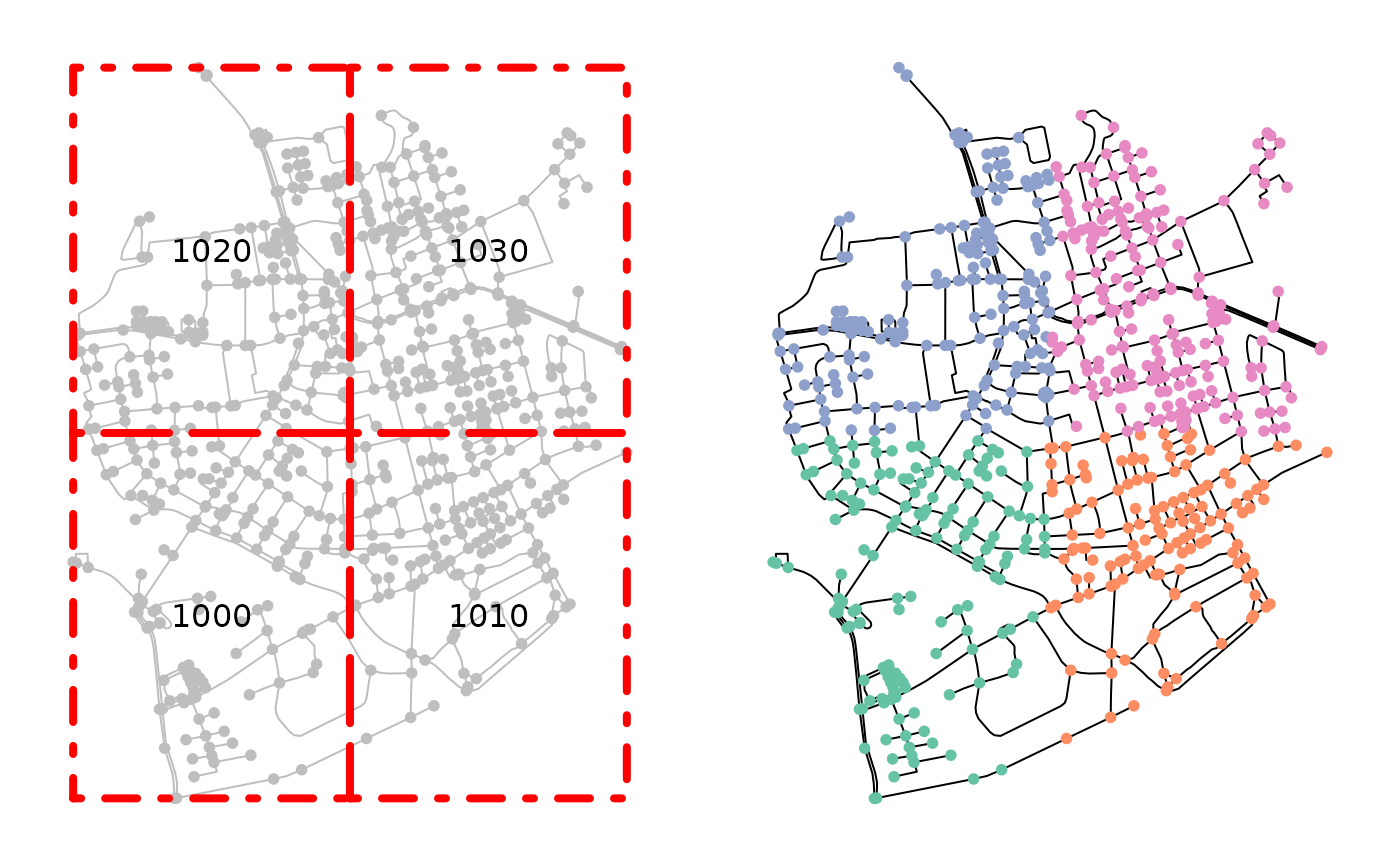 par(oldpar)
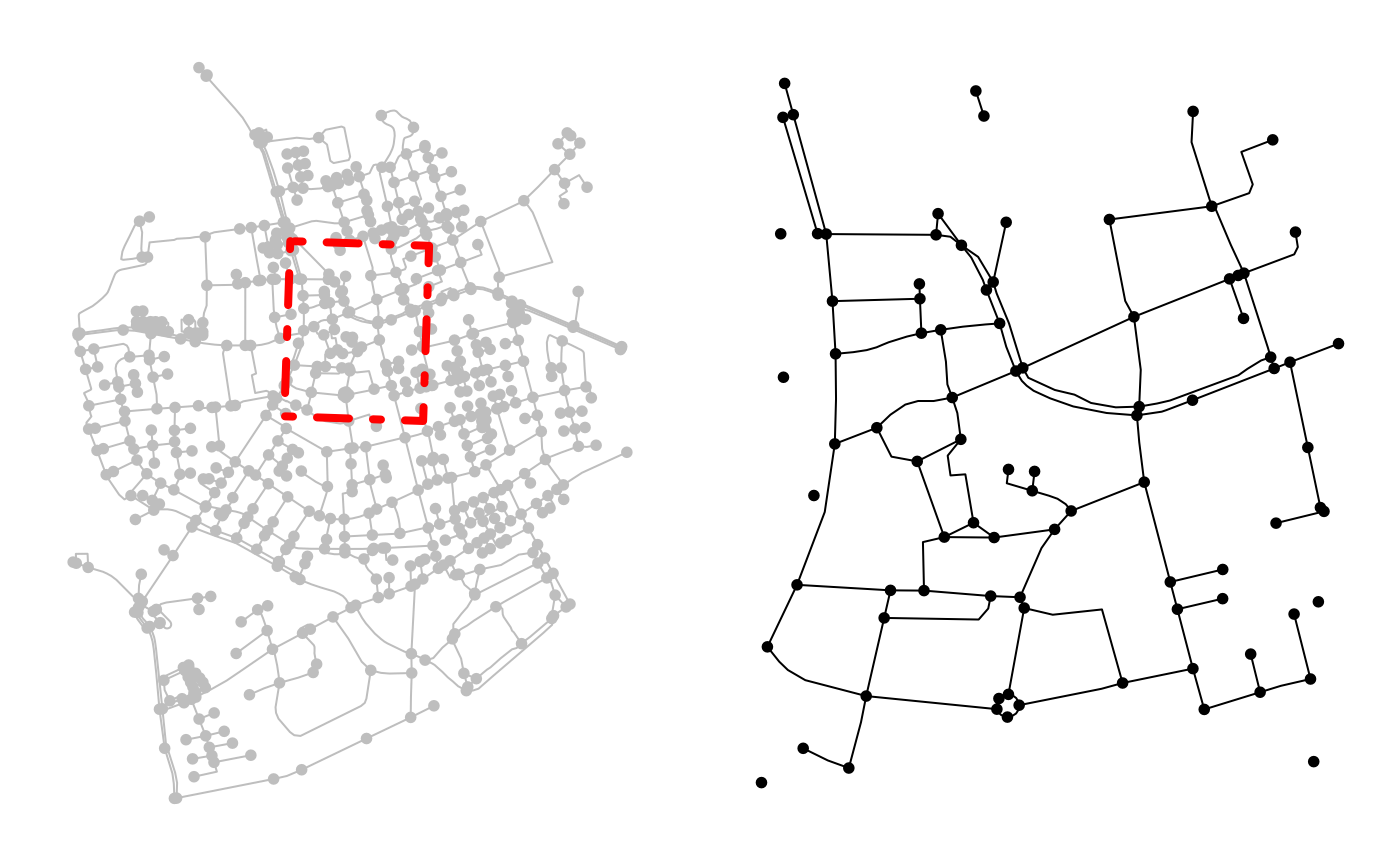
# Spatial filter applied to the active network element.
p1 = st_point(c(4151358, 3208045))
p2 = st_point(c(4151340, 3207520))
p3 = st_point(c(4151756, 3207506))
p4 = st_point(c(4151774, 3208031))
poly = st_multipoint(c(p1, p2, p3, p4)) %>%
st_cast('POLYGON') %>%
st_sfc(crs = 3035) %>%
st_as_sf()
filtered = st_filter(net, poly, .pred = st_intersects)
oldpar = par(no.readonly = TRUE)
par(mar = c(1,1,1,1), mfrow = c(1,2))
plot(net, col = "grey")
plot(poly, border = "red", lty = 4, lwd = 4, add = TRUE)
plot(filtered)
par(oldpar)
# Spatial filter applied to the active network element.
p1 = st_point(c(4151358, 3208045))
p2 = st_point(c(4151340, 3207520))
p3 = st_point(c(4151756, 3207506))
p4 = st_point(c(4151774, 3208031))
poly = st_multipoint(c(p1, p2, p3, p4)) %>%
st_cast('POLYGON') %>%
st_sfc(crs = 3035) %>%
st_as_sf()
filtered = st_filter(net, poly, .pred = st_intersects)
oldpar = par(no.readonly = TRUE)
par(mar = c(1,1,1,1), mfrow = c(1,2))
plot(net, col = "grey")
plot(poly, border = "red", lty = 4, lwd = 4, add = TRUE)
plot(filtered)
 par(oldpar)